On January 14th, White House will be hosting the Safety Datapalooza. The event will focus on safety data resources in the areas of transportation, food, occupational and consumer product safety and disaster preparation and response.
Chicago’s civic innovation community has worked in these areas in some detail and with more data being released, there’s potential for much more work to be done. Below we’ve put together a collection of data sources from local and federal resources and given some examples of safety apps being used around the country.

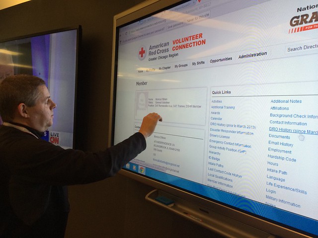
Jim McGowan of the Chicago Red Cross demonstrates the volunteer connection app at the their headquarters.
Data Resources
There is an astounding amount of data regarding public safety. At the federal data portal there are over 800 datasets regarding food, transportation, natural disasters, worker and product safety. We’ve put together a sampling of different data sets that can be used to build civic apps around public safety.
Food Safety
- Chicago: Food Inspection Data
- US HHS: Food Safety Information RSS Feed
- GSA: Recalls API (Covers Food, Drug, Products)
- CDC: Foodborne Outbreak Online Database
Transportation
- Chicago: Historical Chicago Traffic Congestion by Segment (API)
- Chicago: Traffic Tracker by Segment
- Cook County: Highways KML
- Chicago: Raw Data Feed of Chicago Snowplow Truck Locations
- Historical Data for Chicago Snowplows (Via Clearstreets.org)
- US DOT: Trends in Motor Vehicle Crashes (1975 – 2000)
- NHTSA: Fatal Crashes involving speeding in Illinois (2007-2009)
- US DOT: Railroad Accident Data
- NHTSA: Child Safety Seat Inspection Station Locator (API)
- Chicago Bike Crash Map
Fire
- Chicago: Fire Stations
- FEMA: 2010 US Fire Administration Fire (USFA) Fire Incident & Cause Data
- NOAA: Fire Weather Outlooks
Buildings
- Chicago Building Violations
- Chicago 311 Data on Abandoned Buildings
Natural Disasters and Weather Events
- USGS Earthquake Feeds
- NOAA: RSS Feeds for Severe Weather Advisories
- FEMA: Disaster Declarations Summary
- NWS: Tornado Tracks and Icons 1950-2006
- NOAA: Radar Graphics and Data
- Chicago: Warming Centers
Safety on the Job:
- OSHA: Weekly Fatality Reports
- MSHA: Mine Inspections
- OSHA: Chemical Exposure Health Data
Product Safety
- UPSC: All Product Recalls
- UPSC: National Electronic Injury Surveillance System (NEISS) On-line
Safety Apps
Foodborne Chicago
Foodborne Chicago listens to Twitter for reports of food poisoning at restaurants. When the system finds one, it alerts the Chicago Department of Public Health who can reach out to the person through Twitter and asks them to fill out a form. When the form gets filled out, it turns into a 311 Service request for that restaurant to be inspected.
Chicago Bike Crash Browser
This apps shows bike crash data for Chicago in 2005-2012. The app uses data collected by responding law enforcement and maintained by the Illinois Department of Transportation.
EatSafe.Co
This app shows you the food inspection results of restaurants in Chicago. The app also shows you the latest food inspection results that have occurred.
Chicago Plow Tracker
This live map uses GPS devices in every plow truck to show residents the locations of snow plows during snow events in Chicago.
Clearstreets.org
Clearstreets.org uses the City of Chicago’s plow tracking data to show which streets are clear. The app also keeps a record of snow plow locations from previous storms and can provide animations on the plows at work.
OpenStreetMap (HOT Team)
OpenStreetMap – Project Haiti from ItoWorld on Vimeo.
OpenStreetMap is free, collaborative map that anyone can edit. During disasters, the OpenStreetMap community helps humanitarian relief efforts by helping to improve the maps that relief workers use. The Humanitarian OpenStreetMap Team (HOT) helps coordinate the efforts of remote volunteers relief organization on the ground.
ATX Floods
ATX Floods gives real time information on flooding in the Austin, Texas area. This app lets drivers know which roads are closed during a flood event.
Recovers.org
Recovers.org is an organizing toolkit that lets local communites coordinate volunteers during a disaster.
Prepared.ly
Prepared.ly offers a simple interface for emergency preparedness with checklists and facts in order to help residents protect themselves against natural disasters


