SMART CHICAGO IS MOVING!!!

Good News!!! The Smart Chicago team is moving and now will be co-located with the City Digital Team at UI Labs. As such, our individual emails will be changing to:

Kyla Williams           

Sonja Marziano       

Denise Linn               

Leslie Durr               

Our new mailing address is 1415 N. Cherry Avenue Chicago, IL 60642 and general phone number is 312.281.6900.

Please check our website at smartchicagocollaborative.org or follow us on twitter @smartchicago for more updates.

We appreciate your patience during this time of transition.

New Maptime Chicago Event: The Humanitarian OpenStreetMap Team!

hot_logoFor this month’s installment of Maptime, the group is going to put their OSM skills to work contributing to Humanitarian OpenStreetMap Team. Humanitarian OpenStreetMap Team (HOT) applies the principles of open source and open data sharing for humanitarian response and economic development. We will:

  • Learn about the Humanitarian OpenStreetMapTeam (HOT)
  • Get introduced to / do a quick refresher on OpenStreetMap and
  • Dive into contributing to a HOT project using the tasking manager.

We’ve featured the HOT Team before, and have been big fans of their work. If you’ve never seen them in action, here’s a short video showing their work during the aftermath of the earthquake in Haiti.

OpenStreetMap – Project Haiti from ItoWorld on Vimeo.

As you can see, HOT team focuses on mapping roads and infrastructure to help responders navigate through disaster areas.

You can learn more about how you can help the HOT Team by registering for the event here!

Event Details:

When: Thursday, May 28th, 6-8pm
Where: Chicago Community Trust (map) – 225 North Michigan Avenue, #2200. Hosted by Smart Chicago.
Contact: [email protected] or [email protected].

Join the American Red Cross and the OpenStreetMap HOT team this weekend

redcross-logoThe Humanitarian OpenStreetMap Team (HOT Team) is having a dual-mapathon this Saturday, March 28th. It will be hosted at the Red Cross offices of San Diego and Chicago, starting at 11:30AM CST 9:30m PST.

This is going to be one of the first mapathons organized by the Humanitarian OpenStreetMap Team and the Red Cross Regions of San Diego and Chicago. This event will introduce you to OpenStreetMap, the free map of the world, and the Missing Maps project, a collaboration between international humanitarian organizations to map the world’s poorest and most vulnerable urban areas.

Attendees will learn how to use satellite images to create maps of anywhere in the world and help save lives! For more information and to RSVP, please contact: Chicago: Jim McGowan at 312-848-6726 or [email protected] San Diego: Laura Horner at [email protected] or Cristiano Giovando at [email protected]

You can get more information about the event here.

Join us at The Chicago Community Trust for Maptime Chicago!

maptimelogoThe Smart Chicago Collaborative is hosting Maptime Chicago next Thursday at our offices at the Chicago Community Trust (located at 225 N Michigan #2200).

Their first event at the Trust will be a primer on how web maps work. Here’s the event description:

Web maps might look like digital wizardry, but anyone armed with a few basic skills can whip up an awesome-looking web-based map. This beginner-friendly workshop will cover what makes a web map tick. We’ll discuss the technological innovations that brought us to today, the structure of common mapping strategies, and the tools you can use to put your geospatial data on the web.

Maptime is always interactive, so don’t forget to bring your laptop! As always, beginners are very welcome.

Maptime Chicago is part of a larger national organization whose mission is to open the doors of cartographic possibility to anyone interested by creating a time and space for collaborative learning, exploration, and map creation using mapping tools and technologies.

Maptime has a huge list of resources on their website for people wanting to get into map making including introductions to OpenStreetMap, D3 tutorials, QGIS, and more.

You can register for the event here. If you can’t make it in person, we’ll also be livestreaming it on our YouTube page. You can also follow Maptime Chicago on Twitter at @MaptimeChi

Open Street Mappers! Help support the efforts to fight Ebola in West Africa

Since March, the Humanitarian OpenStreetMap Team (HOT) has been supporting the work of Doctors Without Borders by mapping out areas that have been affected by the Ebola outbreak.

osmtaskmanager


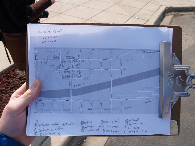
During a disaster, the Humanitarian OpenSteetMap Team (HOT) activates to help coordinate mapping of disaster areas. These activities include mapping out roads, buildings, locations of refugee camps, and other resources. In addition, they also maintain a wiki with information about the disaster. To get an idea of what this looks like, here’s what the OSM community did after the earthquake in Haiti.

OpenStreetMap – Project Haiti from ItoWorld on Vimeo.

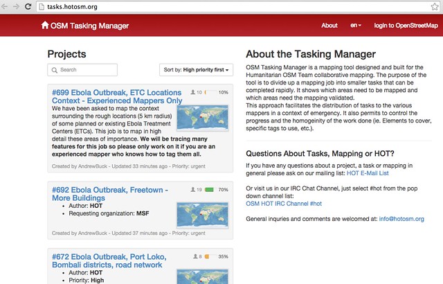
Currently, the Humanitarian OpenStreetMap team is reposonding to several requests from Doctors Without Borders to help map areas affected by the Ebola outbreak. If you’re a beginner with OpenStreetMap, they’re asking for people to map out the roads using Bing imagery. More experienced mappers are being asked to trace out features near Ebola Treatments Centers in West Africa.

If you have an OpenStreetMap account, you can log into the OSM Tasking Manager and select tasks.

If you don’t have an OpenStreetMap account, you can sign up for an account for free here. OpenStreetMap is easy to use and there are several tutorials available, including this one by Chicago’s very own Ian Dees.

If you have time available, please consider spending some time assisting OSM in the effort. For questions directly relating to the HOT Team at OSM, you can email them at [email protected].

Join us Saturday for OpenStreetMap Spring Editathon!

Smart Chicago Collaborative will be hosting an OpenStreetMap Spring #editathon on Saturday, April 26, 2014 from 12:00 – 5:00 PM CST. Ian Dees, a member of the OSM US Board, will be the host of this event. We’re excited to have regular Chicago residents -people who know all about their communities and want to share with the world – to get involved in OpenStreetMap.

Using Google Maps to make a neighborhood map

Photo by Steve Vance

If the weather is nice, we’ll also be going outside to do some hands-on mapping in the Loop. We’ll supply some paper maps, pens, and clipboards to make mapping easier, but bring a phone to take pictures.

This should be a great event for anyone to get involved in mapping their communities and to learn about OpenStreetMap.

If you’ve never used OpenStreetMap, here’s a short video by Ian Dees about how it works.

Let’s start mapping!